Back فيضان الزانكلي Arabic Inundació zancliana Catalan Inundación zancliense Spanish Transgression zancléenne French Banjir Zankleum ID Alluvione zancleana Italian 잔클레 홍수 Korean Lehiya Zanklî Kurdish Zanklos tvanas Lithuanian Banjir Zankle Malay


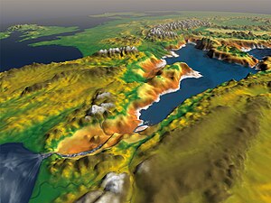
The Zanclean flood or Zanclean deluge is theorized to have refilled the Mediterranean Sea 5.33 million years ago.[1] This flooding ended the Messinian salinity crisis and reconnected the Mediterranean Sea to the Atlantic Ocean, although it is possible that even before the flood there were partial connections to the Atlantic Ocean.[2] The re-connection marks the beginning of the Zanclean age which is the name given to the earliest age on the geologic time scale of the Pliocene.
According to this model, water from the Atlantic Ocean refilled the dried up basin through the modern-day Strait of Gibraltar. Ninety percent of the Mediterranean Basin flooding occurred abruptly during a period estimated to have been between several months and two years, following low water discharges that could have lasted for several thousand years.[3] Sea level rise in the basin may have reached rates at times greater than ten metres per day (thirty feet per day). Based on the erosion features preserved until modern times under the Pliocene sediment, Garcia-Castellanos et al. estimate that water rushed down a drop of more than 1 kilometre (0.6 mi) with a maximum discharge of about 100 million cubic metres per second (3.5 billion cubic feet per second), about 1,000 times that of the present-day Amazon River. Studies of the underground structures at the Gibraltar Strait show that the flooding channel descended gradually toward the bottom of the basin rather than forming a steep waterfall.[4]
- ^ Blanc, P.-L. (2002). "The opening of the Plio-Quaternary Gibraltar Strait: assessing the size of a cataclysm". Geodinamica Acta. 15 (5–6): 303–317. Bibcode:2002GeoAc..15..303B. doi:10.1016/S0985-3111(02)01095-1.
- ^ Efe, Recep (17 March 2014). Environment and Ecology in the Mediterranean Region II. Cambridge Scholars Publishing. p. 11. ISBN 978-1-4438-5773-4.
- ^ Garcia-Castellanos et al. 2009.
- ^ Garcia-Castellanos et al. 2009, p. 778.
© MMXXIII Rich X Search. We shall prevail. All rights reserved. Rich X Search